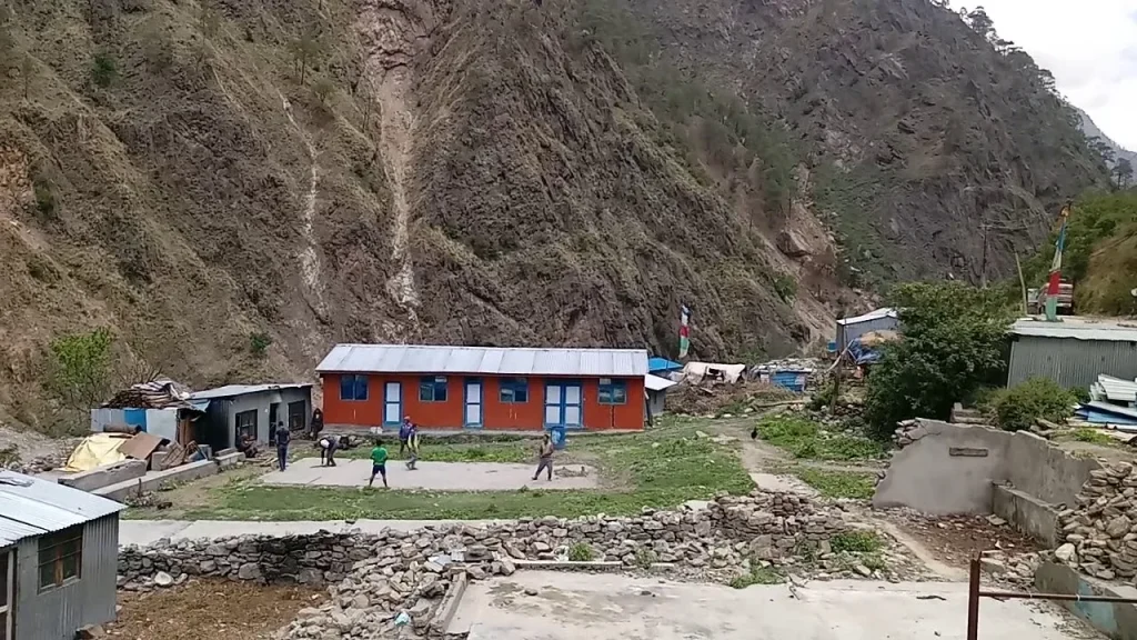
🚨 Critical Emergency Warning: Timure Devastated by Flash Flood
Timure has been severely devastated and nearly swept away by a catastrophic flash flood. All travel to Timure and the upper Bhote Koshi canyon north of Dhunche and Syabrubesi is strictly prohibited. The Pasang Lhamu Highway is impassable. Emergency rescue operations are underway; stay clear of all river corridors and verify local checkpoint advisories immediately.
[gosaikunda_notice_banner]
A Himalayan Border Town & Gateway to Rasuwagadhi
Nestled in the dramatic river gorge of the upper Bhote Koshi in Gosaikunda Rural Municipality–2 of Rasuwa District, Timure (टिमुरे) is a critical cultural crossroads, an essential stop on the Tamang Heritage Trail, and the primary logistics gateway to the Rasuwagadhi Nepal–China border. Located roughly 19 km north of Syabrubesi, Timure uniquely brings together ancient frontier defense heritage, indigenous Tamang village traditions, and contemporary trans-Himalayan commerce.
Quick Facts and Travel Summary
Location: Gosaikunda Rural Municipality–2, Rasuwa District, Bagmati Province, Nepal
Elevation: ~1,900 meters (6,233 ft) above sea level
International Frontier: Nepal–China Border (Rasuwagadhi–Gyirong/Kerung Port)
Primary Trail Network: Tamang Heritage Trail / Langtang National Park Buffer Zone
River Corridor: Upper Trishuli / Bhote Koshi River Basin
Best Visiting Seasons: Autumn (Oct–Nov) & Spring (Mar–May)
Geographic Identity: Timure vs. Rasuwagadhi
While the names Timure and Rasuwagadhi are frequently used interchangeably in travel dispatches, they represent distinct sections of northern Rasuwa’s border corridor:
Timure Settlement: The primary civilian town, customs dry port area, and administrative seat of Gosaikunda Rural Municipality Ward No. 2. It houses immigration staging services, logistics facilities, local markets, and lodges for trekkers and trade personnel.
Rasuwagadhi Border Point: Situated approximately 3 km further north directly at the international boundary line where the Lende and Bhote Koshi rivers converge. It is the site of the active Department of Immigration border checkpoint, the Friendship Bridge to Gyirong (Tibet, China), and the historic stone ramparts of Rasuwa Gadhi Fort.
Key Highlights & Strategic Role
🏛️ Historic Rasuwa Gadhi Fort Ruins
Located 3 km north of Timure, the 19th-century stone fortification preserves a physical testament to the historic Nepal–Tibet and Sino-Nepalese defensive border campaigns.
🥾 Tamang Heritage Trail Integration
Timure connects hikers along the community trekking circuit linking Gatlang, Tatopani, Thuman, and Briddim, offering deep exposure to indigenous architecture and customs.
🚛 Trans-Himalayan Commercial Lifeline
As the overland commercial artery to Gyirong (Kerung), Timure features a dynamic atmosphere where cross-border trade facilities operate alongside mountain village traditions.
🌲 Steep Gorge Scenery & Waterfalls
The terrain between Syabrubesi and Timure showcases dramatic rock gorges, raging glacial river rapids, pine-forested slopes, and plunging seasonal waterfalls.
Visual Route & Travel Connectivity (Kathmandu to Timure)
START / CAPITAL
Kathmandu (Machhapokhari)
(1,400 m | Highway Hub)
➔
DISTRICT HEADQUARTERS
Dhunche Bazaar
(1,960 m | Pasang Lhamu Hwy)
➔
VALLEY TRAILHEAD
Syabrubesi
(1,460 m | Langtang Gate)
➔
DESTINATION
Timure Settlement
(1,900 m | Border Hub)
Transit Modes Breakdown
| Transport Mode |
Duration & Distance |
Route Details & Guidance |
| Drive: Kathmandu to Syabrubesi |
6–8 hrs (~122 km) |
Public bus or private 4WD jeep via Galchhi–Trishuli–Dhunche or the Tokha–Bidur route along the Pasang Lhamu Highway. |
| Road: Syabrubesi to Timure |
1.5–2 hrs (~19 km) |
Local 4WD jeeps and commercial freight transit follow the paved/gravel mountain highway north along the Bhote Koshi canyon. |
| Trek: Tamang Heritage Route |
1–2 Days hiking |
A cultural walking route climbing from Syabrubesi through Gatlang, Tatopani, and Thuman before descending directly into Timure. |
Mandatory Permits & Border Checkpoints
Because Timure lies within the Langtang conservation zone and borders an active international frontier, travelers should prepare the following permits via the Nepal Travel Permits Directory:
| Permit Type |
Applicable Fee |
Regulations & Notes |
| Langtang National Park Entry Permit |
Foreigners: NPR 3,000 + 13% VAT
SAARC: NPR 1,500 + 13% VAT
Nepalis: NPR 100 |
Mandatory for all trekkers; checked at the Dhunche army post and Syabrubesi checkpoints. |
| TIMS Card (Trekker Information Management System) |
NPR 2,000 per person |
Required for organized trekking across the Tamang Heritage Trail and wider Langtang circuits. |
| Border Area / Tibet Transit Documentation |
Subject to Chinese Visa & Tibet Travel Permit (TTP) |
Visiting Timure and Rasuwa Gadhi ruins on the Nepal side requires national park permits. Crossing into Tibet requires pre-arranged bilateral group visas. |
🌟 Nearby Destinations in the Rasuwa Circuit
| Destination / Landmark |
Location / Direction |
Key Highlights & Experience |
| Rasuwa Fort (Rasuwagadhi) |
~3 km North (~1,814 m) |
Explore Rasuwa Fort, the historic stone frontier garrison overlooking the international border river junction. |
| Syabrubesi |
~19 km South (~1,460 m) |
Syabrubesi Hub, the primary roadhead and starting trailhead for both the Langtang Valley and Tamang Heritage circuits. |
| Gosaikunda Holy Lakes (4,380 m) |
South via Dhunche / Thulo Syabru |
Gosaikunda Lake, a sacred high-altitude alpine lake basin revered in Hindu and Buddhist pilgrimage traditions. |
| Kakani, Nuwakot |
Highway Ridge toward Kathmandu |
Kakani Hill Station, famous for trout farms, strawberry agriculture, and panoramic views of the central Himalayas. |
Essential Travel Guidelines & Frontier Etiquette
Do’s
- Carry your original passport, citizenship card, and national park entry permits at all times for verification at army and police checkpoints.
- Carry adequate Nepalese Rupees (NPR) in cash; digital payment terminals and banking services are erratic along the border.
- Respect local Tamang traditions, prayer wheels, and mani walls by passing them on the clockwise side.
Don’ts
- Do not photograph sensitive border security installations, customs screening areas, or military checkpoints around Rasuwagadhi.
- Do not attempt to cross the Friendship Bridge or enter the Chinese territory without authorized international visas and permits.
- Avoid trekking along narrow canyon tracks during heavy monsoon rainfall due to sudden debris flows and rockfall risks.
Frequently Asked Questions (FAQs)
Where is Timure located?
Timure is located in Ward No. 2 of Gosaikunda Rural Municipality in northern Rasuwa District, Bagmati Province, roughly 19 km north of Syabrubesi along the Pasang Lhamu Highway.
How far is the Rasuwagadhi border from Timure?
The international border crossing and historical Rasuwa Gadhi fort ruins are situated approximately 3 km north of Timure (around a 10-minute drive or 45-minute walk).
Is Timure part of the Tamang Heritage Trail?
Yes, Timure is a designated cultural stop on the Tamang Heritage Trail, providing trail links between the northern village of Thuman and the hillside village of Briddim.
Image Credit: Alchetron Youtube
| Information & Feedback Request
If you have updated road clearance status, border opening schedules, or photos to enrich this Timure (Rasuwa) destination profile, please connect with our editorial desk.
|
💬 Send Feedback
|